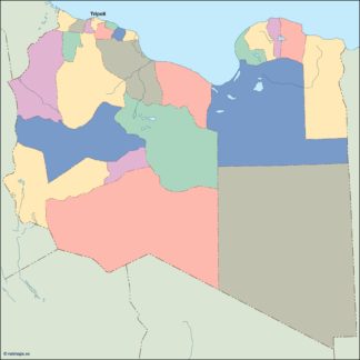
Description
libya vector map. Vector maps from Africa. Illustrator EPS files, fully editable from our African map database. All our digital cartography was created with Vector Adobe Illustrator
Vector eps City maps of the cities and countries of the world. More than 10 000 vector files

39.00 €
illustrator for sale
Libya is a country located in North Africa, bordered by the Mediterranean Sea to the north, Egypt to the east, Sudan to the southeast, Chad and Niger to the south, and Algeria and Tunisia to the west. The capital of Libya is Tripoli, which is located on the northwestern coast of the country.
The map of Libya in EPS vector illustrator format is a highly detailed and accurate representation of the country’s geography. The map includes all major cities, towns, and villages, as well as major highways, roads, and other transportation routes. The map also includes topographical features such as mountains, rivers, and lakes, as well as national parks and other protected areas.
The map is designed to be used in a variety of applications, including print and digital media, web design, and mobile applications. The EPS vector format allows for easy scaling and manipulation of the map, making it ideal for use in a wide range of projects.
The map of Libya is an essential tool for anyone doing business or traveling in the country. It provides a detailed overview of the country’s geography, allowing users to plan routes, locate key landmarks and attractions, and navigate the country with ease.
In addition to its practical applications, the map of Libya is also a beautiful and visually striking piece of artwork. The map is designed in a modern, minimalist style, with bold colors and clean lines that make it easy to read and understand.
Overall, the map of Libya in EPS vector illustrator format is an essential tool for anyone doing business or traveling in the country. Its accuracy, detail, and visual appeal make it a valuable asset for a wide range of applications, and its versatility and ease of use make it an ideal choice for designers, developers, and other professionals.
libya vector map. Vector maps from Africa. Illustrator EPS files, fully editable from our African map database. All our digital cartography was created with Vector Adobe Illustrator