Description
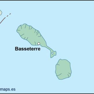
st kitts and nevis vector map. Vector maps from Central America and Caribe Illustrator EPS files, fully editable from our American Country map database. All our digital cartography was created with Vector Adobe Illustrator
Vector eps City maps of the cities and countries of the world. More than 10 000 vector files

39.00 €
St. Kitts and Nevis is a small island nation located in the Caribbean Sea. The country is made up of two main islands, St. Kitts and Nevis, and several smaller islands. The capital city of St. Kitts and Nevis is Basseterre, which is located on the island of St. Kitts.
The country is located in the eastern Caribbean Sea and is part of the Lesser Antilles. It is situated to the east of Puerto Rico and the Virgin Islands, and to the north of Trinidad and Tobago. The country is also located to the west of Antigua and Barbuda.
The St. Kitts and Nevis EPS map vector is a detailed map of the country that includes all of the major cities, towns, and landmarks. The map is designed to be used in a variety of applications, including tourism, education, and business.
The map is created using vector graphics, which means that it can be scaled to any size without losing quality. This makes it ideal for use in large format printing, such as billboards and posters.
The St. Kitts and Nevis EPS map vector includes all of the major roads and highways, as well as the locations of airports, seaports, and other transportation hubs. The map also includes the locations of major tourist attractions, such as beaches, parks, and historical sites.
The map is designed to be easy to read and understand, with clear labels and symbols for each location. The colors used in the map are bright and vibrant, making it visually appealing and engaging.
Overall, the St. Kitts and Nevis EPS map vector is an essential tool for anyone looking to explore or do business in this beautiful island nation. Its detailed and accurate information makes it a valuable resource for tourists, educators, and business professionals alike.
st kitts and nevis vector map. Vector maps from Central America and Caribe Illustrator EPS files, fully editable from our American Country map database. All our digital cartography was created with Vector Adobe Illustrator